


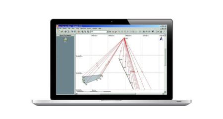
X-TOPO module allows to import the measurements from your instruments and have the full control of all the information to verify at any time the quality of your work. It calculates and solves all kinds of surveys, GNSS, total station, digital level and mixed with the least squared algorithms for precise calculation.

Office X-TOPO Server Licence
2.625,00 € χωρίς Φ.Π.Α.
Description
From topographic points or point clouds it is possible to create 3D models, contour lines, calculate cross-sections and volumes using several methods. Powerful tools and options allow you to customize the final drawings to obtain the best results possible for you customers.
Related products
-

-

-
-
 3.780,00 € χωρίς Φ.Π.Α.
The X-PHOTO Image Processing Modules enable you to process images and generate point clouds and 3D surfaces quickly and accurately.

